
In the past week Storm Dudley, Storm Eunice and Storm Franklin have battered the UK, sending buildings, bins and blow-dries into despair. But now, there have been rumours of Storm Gladys taking the reins after winds reached 80mph and left millions without power.
READ: Who is looking after the Queen as she isolates with COVID-19 at Windsor Castle?
Floods, power cuts and transport issues have been brought on by gale-force winds and heavy rainfall, with transport officials asking people to avoid using public transport unless totally necessary.
WATCH: The Queen's home is affected by extreme weather
The Met Office has told the public to expect further transport delays and rail closures in the upcoming days while expressing specific concern regarding the safety of those living in Northern Ireland. With ominous tornado warnings now being thrown into the mix, what can we expect from the British weather this week - and should we be worried about Storm Gladys?
Unfortunately, the tempestuous weather is here to stay but there is a light at the end of the tunnel. HELLO! spoke to BBC Look North in Yorkshire presenter Abbie Dewhurst for further insight.
SEE: How to avoid pricey damage to your home before Storm Eunice hits
She explained: "Our weather really has been wild during the past few days here in the UK with three named storms in a week. The strength of the winds has caused issues across the board with potentially the highest wind gust ever recorded in England of 122mph on the Isle of Wight. It wasn't just wind though, we also had some disruptive snowfall across Scotland and Northern England and some very heavy rain which has led to some devastating flooding."
 © Photo: Rex
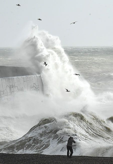
Storm Franklin wreaked havoc across the UK with 87mph winds
This is the first time that three storms have been named within a week since the storm naming system began in 2015 – a rare occurrence for the UK. The weather expert, who boasts 59k followers on TikTok, added: "The jet stream which is a feed of strong winds sat around 5-7 miles above the Earth's surface that drives our weather, is staying very active. This means our weather is set to stay quite unsettled through much of the week with rain or showers and some quite strong winds."
RELATED: Winter weather driving tips: How to drive safely when snow, ice or fog is forecast
However, the BBC is yet to name any future storms at the moment despite rumours of Storm Gladys surfacing, a potential utterance of good news. There's even a glimmer of hope that the storms' bitter chill will soften: "There will be a bit of sunshine mixed in though and it does look to stay a little bit milder – a little silver lining!"
Like this story? Sign up to our HELLO! newsletters to get other stories like this delivered straight to your inbox.